The Hanging Garden of Babylon


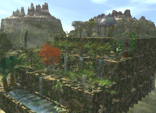
The Hanging Garden of babylon also known as the Hanging garden of Semiramis, near present-day Al-Hillah, Babil in Iraq, are considered to be one of the original Seven Wonders of Ancient World. They were built by the Chaldean king Nebuchadnezzar around 600 BC. He is reported to have constructed the gardens to please his homesick wife, Amytis of Media who longed for the trees and fragrant plants of her homeland Persia. The gardens were destroyed by several earthquakes after the 2nd century BC.The lush Hanging Gardens are extensively documented by Greek Historian such as Strabo and Diodorus. Through the ages, the location may have been confused with gardens that existed at Nimrud since tablets from there clearly show gardens. Writings on these tablets describe the possible use of something similar to an Archimedes screw as a process of raising the water to the required height. Nebuchadnezzar II also used massive slabs of stone, which was unheard of in Babylon, to prevent the water from eroding the ground.

There is some controversy as to whether the Hanging Gardens were an actual creation or a poetic creation due to the lack of documentation of them in the Chronicles of Babylonian history. In ancient writings the Hanging Gardens of Babylon were first described by Berossus, a Chaldean priest who lived in the late 4th century BC. These accounts were later elaborated on by Greek historians.A more recent theory proposes that the gardens were actually constructed under the orders of Sennacherib, who took the throne of Assyria in 705 BC, reigning until 681 BC. During new studies of the location of Nineveh (Located on the eastern bank of the Tigris in ancient Assyria) his gardens were placed close to the entrance of his palace, on the bank of the River Tigris. It is possible that in the intervening centuries, the two sites became confused, and the hanging gardens were attributed to Babylon.

Greek References :

The Greek Historian Strabo :

"Babylon, too, lies in a plain; and the circuit of its wall is three hundred and eighty-five stadia. The thickness of its wall is thirty-two feet; the height thereof between the towers is fifty cubits that of the towers is sixty cubits; the passage on top of the wall is such that four-horse chariots can easily pass one another; and it is on this account that this and the hanging garden are called one of the Seven Wonders of the World. The garden is quadrangular in shape, and each side is four plethra in length. It consists of arched vaults, which are situated, one after another, on checkered, cube-like foundations. The checkered foundations, which are hollowed out, are covered so deep with earth that they admit of the largest of trees, having been constructed of baked brick and ashpalt the foundations themselves and the vaults and the arches. The ascent to the uppermost terrace roofs is made by a stairway; and alongside these stairs there were screws, through which the water was continually conducted up into the garden from the Euphrates by those appointed for this purpose. For the river, a stadium in width, flows through the middle of the city; and the garden is on the bank of the river.

The Greek Historian Diodorus:

"The Garden was 100 feet (30 m) long by 100 ft wide and built up in tiers so that it resembled a theatre. Vaults had been constructed under the ascending terraces which carried the entire weight of the planted garden; the uppermost vault, which was seventy-five feet high, was the highest part of the garden, which, at this point, was on the same level as the city walls.The roofs of the vaults which supported the garden were constructed of stone beams some sixteen feet long, and over these were laid first a layer of reeds set in thick tar, then two courses of baked brick bonded by cement, and finally a covering of lead to prevent the moisture in the soil penetrating the roof. On top of this roof enough topsoil was heaped to allow the biggest trees to take root. The earth was leveled off and thickly planted with every kind of tree. And since the galleries projected one beyond the other, where they were sunlit, they contained conduits for the water which was raised by pumps in great abundance from the river, though no one outside could see it being done.



  • Digg
  • Del.icio.us
  • StumbleUpon
  • Reddit
  • Twitter
  • RSS

Iguazu Falls


The waterfall system consists of 275 falls along 2.7 kilometers (1.67 miles) of the Iguazu River. Position is at latitude (DMS): 25° 40' 60 S, longitude (DMS): 54° 25' 60 W . Some of the individual falls are up to 82 meters (269 ft) in height, though the majority are about 64 metres (210 ft). The Devil's Throat (Garganta del Diablo in Spanish or Garganta do Diabo in Portuguese), a U-shaped, 82-meter-high, 150-meter-wide and 700-meter-long (490 by 2300 feet) cataract, is the most impressive of all, and marks the border between Argentina and Brazil. Two thirds of the falls are within Argentine territory. About 900 meters of the 2.7-kilometer length does not have water flowing over it. The edge of the basalt cap recedes only 3 mm (0.1 in) per year. The water of the lower Iguazu collects in a canyon that drains into the Parana River at Argentina, shortly downstream from the Itaipu dam.
The falls can be reached from the two main towns on either side of the falls: Foz do Igacu in the Brazilian state of Paraná, and Puerto Iguazu in the Argentine province of Misiones as well as from Ciudad de Este (Paraguay) on the other side of the Parana river from Foz do Iguaçu. The falls are shared by the Iguazu National Park (Argentina) and Iguacu National Park (Brazil). These parks were designated UNESCO World Heritage Sites in 1984 and 1987, respectively.
On the Brazilian side there is a long walkway along the canyon with an extension to the lower base of the Devil's Throat. From Foz do Iguaçu airport the park can be reached by taxi (R$ 15-17) or bus (no 120) to entrance of the park. There is an entrance fee to the park. Free frequent buses are provided to various points within the park.The park opens at 9 am and closes at 5.30 pm. The town of Foz do Iguaçu is about 20 kms away and the airport is in between the park and the town.
The Argentine access is facilitated by the Tren Ecológico de la Selva (Rainforest Ecological Train), which brings visitors to different walkways. The Paseo Garganta del Diablo is a one-kilometer-long trail that brings the visitor directly over the falls of the Devil's Throat. Other walkways allow access to the elongated stretch of falls on the Argentine side and to the ferry that connects to the San Martin Island.

  • Digg
  • Del.icio.us
  • StumbleUpon
  • Reddit
  • Twitter
  • RSS

Buckingham Palace, England


Buckingham Palace adalah kediaman resmi Ratu Inggris di London. Istana ini adalah tempat untuk peristiwa-peristiwa kenegaraan, tempat menyambut tamu negara, dan tempat kunjungan pariwisata. Seringkali dalam masa-masa kegembiraan, krisis atau perkabungan, tempat ini juga menjadi pusat berkumpul untuk masyarakat Britania Raya.Bangunan ini sebelumnya dikenal dengan nama Buckingham House, gedung yang dipergunakan sekarang ini dan menjadi tempat kunjungan dari para wisatawan asing, sebenarnya adalah sebuah balai kota yang dibangun untuk Duke of Buckingham pada tahun 1703 dan diambil alih oleh George III pada tahun 1761 dan dijadikan sebagai rumah pribadi yang dikenal sebagai "The Queen's House". Bangunan ini sudah mengalami pengembangan dari sejak dibangun, secara dasar oleh arsitek John Nash dan Edwaard Blore sehingga menghasilkan tiga gedung sayap tambahan dari halaman tengah. Buckingham Palace akhirnya menjadi kediaman resmi dari keluarha kerajaan Britania Raya sejak pengangkatan Raty Victoria pada tahun 1837. Penambahan terakhir dari gedung ini dibuat pada akhir abad ke-19 dan awal dari abad ke-20, termasuk didalamnya bagian depan yang sering kita lihat sekarang dari Buckingham Palace. Bangunan ini juga masih beberapa kali direferensikan sebagai "Buck House".

Desain interiornya didominasi oleh hiasan yang berasal dari awal abad ke-19, dimana masih banyak juga yang dipajang hingga sekarang, termasuk penggunaan warna-warna cerah yang dikenal dengan teknik scagliola dan biru serta merah jambu lapis, yang merupakan saran dari Sir Charles Long. King Edward VII melakukan perubahan perubahan dekorasinya dan menambahkan Belle Epoque cream dan warna-warna keemasan. Banyak ruangan untuk menerima tamu dalam ukuran kecil yang dilengkapi dengan furnitur-furnitur Cina yang dibawa dari Royal Pavilion yang terletak di Brighton dan dari Carlton House setelah wafatnya King George IV. Buckingham Palace Garden adalah taman milik pribadi yang terbesar di London, dimana desainnya dirancang oleh ahli pertamanan Capability Brown namun dirancang ulang oleh William Townsend Aiton dan John Nash. Danau buatannya selesai dibuat pada tahun 1828 dan diisi air dari Serpentine, sebuah danau yang terletak di Hyde Park.Didalam gedung ini juga ada satu ruangan yang dipergunakan sebagai ruangan kerja dari Queen Elizabeth II dan keluarga kerajaan untuk acara maupun jamuan resmi kenegaraan. Gedung ini merupakan salah satu gedung yang sangat popular dan dikunjungi oleh wisatawan tak kurang dari 50,000 orang per tahunnya untuk menghadiri jamuan makan malam, makan siang, resepsi dan pesta-pesta resmi keluarga kerajaan.

Sejarah :

Pada abad pertengahan, area Buckingham Palace membentuk area dari "Manor of Ebury" (yang juga dikenal dengan "Eia"). Namun area tersebut sekarang sudah menjadi satu dengan sungai Tyburn yang masih mengalir hingga sekarang, di arah selatan dari istana. Kepemilikan dari area ini pernah berpindah tangan beberapa kali, dari Edward the Confessor, Edith of Wessex pada akhir-akhir zaman Saxon, dan sesudah Norman Conquest, William the Conqueror. William kemudian memberikan area ini kepada Geoffrey de Mandeville, yang menyerahkannya kepada biarawan dari Westminster.Pada tahun 1531, Henry VIII mengakusisi Rumah Sakit St James dari Eton College, dan pada tahun 1536 ia membeli Manor of Ebury dari Westminster Abbey. Proses ini menjadikan area Buckingham Palace kembali ke tangan kerajaan untuk pertama kali sejak William "Sang Penakluk" memberikannya kepada orang lain selama kurun waktu tidak kurang dari 500 tahun lamanya.

  • Digg
  • Del.icio.us
  • StumbleUpon
  • Reddit
  • Twitter
  • RSS

City of Petra


Petra terletak di Yordania barat-daya sekitar 50 mil (80 kilometer) sebelah selatan Laut Mati,dikeliling batu karang dan pasir yang menjadi perlindung alami dari serbuan pihak luar. Batu karang yang menjulang tinggi ini seolah menjadi benteng bagi Petra.
Letak Petra yang strategis menjadi jalur bisnis utama pada masa itu. Hal itu terlihat dari sisa-sisa bangunan yg kokoh tak yg lekang oleh waktu. Ribuan tahun telah berlalu, namun bentuk bangunan di kota kuno itu masih terlihat jelas.
Dulunya, boleh dibilang Petra merupakan kota yg maju karena menjadi jalur pusat perdagangan berbagai jenis barang, mulai dari sutera, rempah-rempah, dll. Petra menjadi jalur bisnis penting yg menghubungankan Cina, India dan sebelah selatan Arab seperti Mesir, Suriah, Yunani dan Roma.
Setelah ribuan tahun kota itu 'hilang' kini jalan mencapai Petra tidaklah mudah. Satu-satunya akses menuju kota kuno itu adalah melewati jalan sempit dan gelap sepanjang 2 km. Mungkin dulunya itu merupakan sebuah jurang. Lebarnya hanya 3-4 meter, di antara batu karang yang menjulang setinggi 100 meter.
Orang menyebut jalan itu Siq. Nah begitu berhasil melewati Siq, sampailah anda di City of Petra, kota kuno yang masih memperlihatkan sisa sisa kemegahannya di masa lalu.

  • Digg
  • Del.icio.us
  • StumbleUpon
  • Reddit
  • Twitter
  • RSS

Machu Picchu...Lost City of Incas


Machu Picchu was first brought to the attention of the world in 1911.The Spanish Invaders at the time of the Conquest never discovered the city and nobody ever led them there , suggesting that the site had long since been abandoned and forgotten.
Mavhu Picchu is a "Inca" town sited in the saddle between two mountains , Machu Picchu (Old Mountain) ,and Huayna Picchu (Young Mountain) , Peru. The buildings all constructed by local stone. After centuries lost in the jungle of Cuzco ,Machu Picchu was rediscovered in 1911 by American archeologist Hiram Bingham. The Inca trail to Machu Picchu is rated as one of the best trekking trails in the world offering stunning landscapes and ancient ruins with diverse ecology.
Most of the construction in Machu Picchu uses the classic Inca architectural style of polished dry-stone walls of regular shape. The Incas were masters of this technique, called ashlar, in which blocks of stone are cut to fit together tightly without mortar.
Other Inca buildings have been built using mortar, but by Inca standards that was quick, shoddy construction. Peru is a highly seismic land, and mortar-free construction was more earthquake-resistant than using mortar. Inca walls show numerous subtle design details that would prevent them from collapsing in an earthquake.
Doors and windows are trapezoidal and tilt inward from bottom to top, corners are usually rounded, inside corners often incline slightly into the rooms, and "L" shaped blocks are often used to tie outside corners together. Walls do not rise straight from top to bottom but are offset slightly from row to row. As a result, Machu Picchu is a city that has stood up well to earthquakes over the years.
According to archaeologists, the urban sector of Machu Picchu was divided into three great districts: the Sacred District, the Popular District, to the south, and the District of the Priests and the Nobility.
On July 7, 2007, Machu Picchu was voted as one of New Open World Corporation's New Seven Wonders of the World.

  • Digg
  • Del.icio.us
  • StumbleUpon
  • Reddit
  • Twitter
  • RSS

The Great Temple of Abu Simbel


Abu Simbel are two massive rock temple in Nubia , southern Egypt on the western bank of Lake Nasser about 290 km southwest of Aswan.The twin temples were originally carved out on the mountainside during the reign of Pharaoh Ramesses II in the 13th century BC, as a lasting monument to himself and his queen Nefertari, to commemorate his alleged victory at the Battle of Kadesh, and to intimidate his Nubian neighbor. The Great Temple of Abu Simbel was also relocated in 1964.The relocation was necessary to avoid their submerged during the creation of Lake Nasser.Abu Simbel remains one of Egypt's top tourist attractions.
The Great Temple of Abu Simbel took about 20 years old to built which was completed around year 24 of the reign of Ramesses.It was dedicated to God Amun, Ptah, Ra-horakhty, and it also to the deified Ramesses himself.

  • Digg
  • Del.icio.us
  • StumbleUpon
  • Reddit
  • Twitter
  • RSS